Awaiting the Ship's Arrival
The RRS Shackleton is on it's way to relieve the base. The ship will take away our rubbish and empty fuel drums and give us (in order of importance) post, food, fuel and spares. Oh and new people. Lots of them. At the moment there's 19 people on base (3 managers flew in with the Germans last Saturday), and the ship is teeming with people - lots of people.
So, where is it and when's it going to get in?
Well - it's due in on the 21st of December, but there's a lot of sea ice about at the moment.
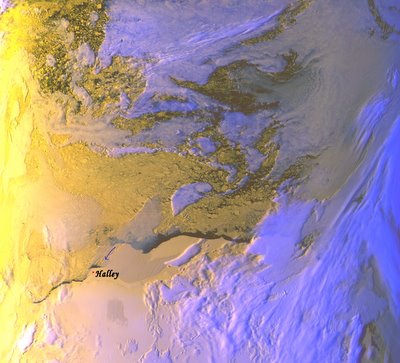
 Click on the picture to see a larger image.
This is an image picked up by our satellite imager the Dartcom HRPT. It was taken around 5pm (local time) on the 17th of December. The image is made up of 3 channels recording at 3 different wavelength bands and are represented by blue, red and green. In this image white and light blue is cloud, the yellow & peach is ice and snow, and the black is open water. You can't distinguish fast ice and shelf ice on the Satellite image but we actually have around 5km of fast ice (thin 1st year sea ice) around our iceshelf. That's what the Penguins are living on. Beyond this is open water, which is promising for the ship. The problem is the build up of seaice against the Stancomb-Wills ice shelf (blue arrow) which is where the ship normally finds open water. There's a bit of cloud over this bit of the picture, but we think it's pretty dense icepack. Beyond the open water is a lot of pack ice. It's difficult to tell how thick or solid it is or to guess how well the ship will get through it.
This all of course depends on weather. If we get a strong Easterly wind it will blow all of the sea ice out of the way, but then there's a risk that it destroys the fast ice that the Penguins are living on and the chicks all die - again.
You can track the ship by clicking here, and the latest webcam out the rear of the ship here.This is one of the pros/cons of living in such a remote place. All we can do is place bets and wait for post.


